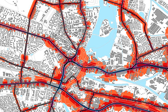
Noise mapping according to directive 2015/996 with IMMI (CNOSSOS-EU)
Noise mapping, exposure analysis, and action plans – IMMI is just the right software for these challenging tasks
The issue of noise emissions and immissions plays an important role in urban planning processes. You can use IMMI's full range of features for corresponding investigations: the import of GIS data sets, automated segmented calculation in the network, the creation of calculation lists for comparison of different variants or exposure analyses.
Probably the most challenging task is noise mapping according to the EU directive. IMMI has been and still is used successfully in numerous projects: whether for a city like Berlin, federal states like Bavaria or Baden-Württemberg, or for counties in the UK.

Noise mapping according Directive (EU) 2021/1226 for road traffic noise, railway noise, industrial noise and aircraft noise (CNOSSOS-EU)
- According to CNOSSOS-EU with national implementation all over Europe
- Throughout the EU according to national regulations
- In Germany, in accordance with the requirements of the noise mapping regulation (34. BImSchV) combined with §§ 47 a-f BImSchG
The calculation of strategic noise maps for the noise indicators LDEN and LNight is carried out in 10 m increments and at a height of 4 m, separately for each type of noise. The exposure analysis for evaluation of the affected persons according to directive 2015/996 is realized by calculating facade levels. The performance features multicore, segmented calculation, and ACC – distributing the calculation in the network – are for the calculation of noise maps and facade levels on any number of computers ensuring short computing times.
Powerful functions for noise mapping support you in executing your projects
- Quality assured according directive (Testcases from Germany) ISO/TR 17534-4:2020 und BUB, BEB, BUF
- Data import etc. via: .OSM, .XML, ArcGIS, QSI, DXF, ASCII, CityGml
- Unlimited number of obstacles (buildings, walls)
- Support of large-size terrain models and simplifying functions
- Input of the building use (e.g. residential building, school, kindergarten, hospital, uninhabited), number of storeys, dwellings, inhabitants
- Automatic calculation in the network
- Numerous control functions for quality assurance
- Data export
- Evaluation functions: Create conflict maps, hotspot analysis, differential grids.
- Exposure analysis according to Directive (EU) 2020/367 for the assessment of adverse health effects of environmental noise as well as the national implementation according to 34. BImSchV.
Noise action plans
With noise action plans, cities and municipalities have a considerable influence on the reduction of road traffic noise. For noise action plans, we determine hot spots, develop reduction concepts in close collaboration with the planning committees, demonstrate the effectiveness of measures, plan quiet areas and provide support in reporting to the EU.
Please contact me personally
________
I am happy to support you with questions concerning the functionalities and application areas of IMMI – before purchase, during implementation and in daily use.


![[Translate to English:] [Translate to English:]](/fileadmin/_processed_/b/f/csm_2020-03-kachel-immi-veranstaltungen_d3b2d7fbcd.jpg)